Tropical Storm Warning Issued for Eastern Seaboard Ahead of Weekend Rain and Wind Threat
A tropical storm warning has been issued for regions along the North Carolina and mid-Atlantic coasts in anticipation of an evolving storm system. This storm is poised to bring about blustery winds, torrential rainfall, perilous rip currents, and potential coastal inundation across a stretch from Florida to New England, as it tracks northward near the coastline throughout the upcoming weekend.
The area of low pressure, currently identified as Potential Tropical Cyclone 16 by the National Hurricane Center, is presently exhibiting winds of 35 mph off the eastern coast of Florida. The National Hurricane Center anticipates its progression into a tropical storm by Friday, especially as it nears the North Carolina shoreline. Depending on its timing, it could be named either Ophelia or Philippe.
The tropical storm warning has been issued for the region extending from just south of Wilmington, North Carolina, to the Maryland-Delaware state line. North Carolina may experience tropical storm-force winds as early as Friday, followed by the mid-Atlantic region on Saturday.
Additionally, a storm surge watch has been issued for areas along the same coastal stretch, with the potential for surges of up to 4 feet, spanning from Surf City, North Carolina, to the Virginia Tidewater.

As of Thursday, the storm was gradually intensifying, triggering the development of rainfall and thunderstorms along the northeastern coast of Florida and the southeastern reaches of Georgia. Breezy conditions have also caused seas to become increasingly turbulent, but the most severe impacts of the storm are forecasted for this weekend.
Anticipated Unpleasant Weekend Weather Along the Eastern Seaboard Widespread Rainfall
As the coastal storm system becomes better organized on Friday, precipitation will shift into the Carolinas and Virginia. Rainfall will extend hundreds of miles from the storm’s center as it advances northward throughout the weekend, drenching parts of the mid-Atlantic on Saturday and even reaching portions of New England by Saturday night.
While the heaviest rainfall is expected to remain predominantly near the coast, inland areas will still contend with inclement weather, potentially disrupting outdoor plans.
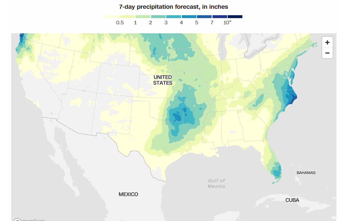
Anticipated Rainfall Distribution This Week Cumulative precipitation and other weather forecasts for the upcoming seven days.
The highest risk for heavy rainfall and flooding lies in far eastern North Carolina, where accumulations of 4 to 6 inches are likely.
Over the course of Saturday and Sunday, two to 4 inches of rainfall could affect a broader swath of the eastern United States, spanning from central North Carolina to New Jersey and New York. Even southern New England and inland regions such as Pennsylvania may see 1 to 2 inches of precipitation this weekend.
Strong Winds
Coastal regions can expect increasing wind speeds on Friday, with gusts reaching 30 to 40 mph, and even higher gusts possible closer to the storm’s center. The most potent winds are predicted to arrive on Friday for parts of the Carolinas and then propagate northward into the mid-Atlantic later on Friday and into Saturday.
These wind gusts, combined with saturated ground, raise the risk of downed trees, potentially causing property damage and power outages.
Coastal Hazards
As the storm tracks north, the potential for hazardous rip currents will be elevated along most of the East Coast, creating perilous sea conditions. The weather service has issued a high-risk warning for rip currents leading into the weekend, affecting sections of the coastline from Florida to New Jersey.
Coastal flooding is also a concern for regions from North Carolina northward into New Jersey as the storm progresses up the coast during the weekend. The forecast includes major to moderate flooding in several locations within the Virginia Tidewater and along Delaware Bay on Saturday, driven by the storm’s strong winds pushing water into rivers along the coast.
In areas where major flooding occurs, a significant number of roads, residences, and businesses could potentially be inundated, as outlined by NOAA.